Tag Archives: geotag
February 8, 2013

From Tashkent to the Fergana Valley

After 16+ hours of being stuffed like a sardine in a can (but with free German beer!), I landed in Tashkent around 10pm. It took two hours to clear passport control and customs, so I didn’t arrive to my hotel until around midnight. Instead of going directly to bed, like any sane person would, I spent some time Tweeting/Facebooking/whatever and finally crashed at 2:30am.

And before I knew it, I was awake again at 6am and headed to the Fergana Valley, a five hour drive away. Uzbekistan has interesting radio stations, by the way. One minute they’ll be playing the Beatles’ “Back in the USSR” (ironic, no?) and the next minute MC Hammer’s “Too Legit to Quit”. Yes, MC Hammer.

Tashkent itself appeared to be like every other post-Soviet city I had previously traveled to, with plenty of communist block apartments, wide boulevards, and grandiose monuments. Although I didn’t see sheep grazing in the medians of Kiev and Moscow, so that was something new. But those were just cursory observations; I would return to Tashkent a few days later to explore further.

Outside the city limits of Tashkent, the scenery changed to cotton fields and herders driving their cattle along the roadside. In the small towns along the highway, old men gathered at dilapidated chaikhanas to sip tea and trade stories. Dozens of cars waited patiently at the entrances of palatial gas stations that have no gas to dispense; it reminded me of scenes from the Energy Crisis in the 1970s.

We began to climb the winding roads leading higher into the mountainous terrain. The views from up there were spectacular, interrupted only by the occasional police checkpoint and massive tunnels bored through the mountains, guarded at each end by Kevlar clad, Kalashnikov toting soldiers.

Finally through the mountains, we arrived in the Fergana Valley, the cotton and bread basket of Uzbekistan. Pull up the region on Google Maps and you’ll see an oasis of green surrounded by the dry, desert Tien-Shan and Gissar-Alai mountain ranges. On our way to Rishtan, where I was rendezvousing with my company’s tour group (oh yeah, did I mention this was a work trip?) we passed miles of cotton fields being picked by (mostly) women workers. There is no mechanical harvesting in Uzbekistan, so these women endure hours of back-breaking work to provide for their families. Driving further, we passed barren fields where dozens of large seismic trucks idled. Yes, the Chinese oil companies are here, eagerly searching for that black gold. My eyes began to sting – we traded our fresh mountain air for the dust and smoke of the valley. It smelled of burning trash and agricultural waste.

I’m embarrassed to admit that prior to this trip I had little knowledge of this region of Central Asia. Up until now, the only things I associated it with were ethnic conflict and Islamic fundamentalism. One of my grad school professors was slightly obsessed with these topics, so we spent a lot of class time covering them. Thankfully this visit would give me a chance to learn a bit more about the region.

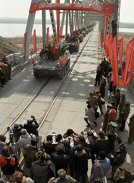
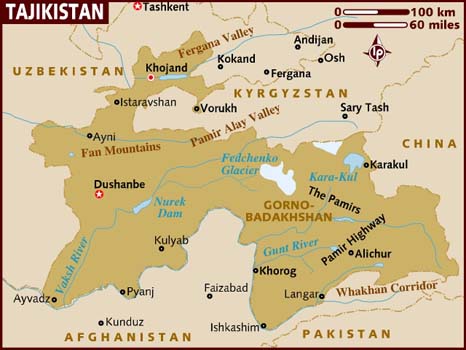
The Fergana Valley encompasses portions of three countries – Uzbekistan, Kyrgyzstan, and Tajikistan – but in reality the entire region is a jumble of ethnicities, rather than clearly delineated by borders. You’ve got some Uzbeks living in Kyrgyzstan and Tajikistan, some Kyrgyz living in Uzbekistan, Tajiks in Kyrgyzstan, and well, you get the idea. The ethnic conflicts that erupted as the Soviet Union collapsed, and which continue to this day, have their origins in the 1920s, when Josef Stalin arbitrarily divided Central Asia into Soviet Republics without any regard for ethnicity.

fergana valley ethnic groups From Tashkent to the Fergana Valley
Source: The Economist

I met up with our tour group and we headed to Kokand, a city of 192,000 that has existed since the 10th century, and, like most things in Central Asia, was razed to the ground by the Mongols in the 13th century. This would be a recurring theme of our travels throughout the region.

Here we visited the Palace of Khudáyár Khán, home of the last ruler of the Khanate of Kokand. The Khanate of Kokand was a Central Asian state that was established in 1709. But in the 1870s the Russians arrived and abolished the Khanate, declaring it part of Russian Turkestan.

Yes, finally, pictures:


Entrance to the palace


These guys asked me to take their picture, so I did.

After visiting the palace we had a few hours to rest at the hotel before dining at the home of a local family. They served the Fergana version of plov, which is the national dish of Uzbekistan and incredibly tasty. Seriously, it is one of my favorite comfort foods and I would eat it every day if I could. Lamb, rice, carrots, onions, and spices – how can you go wrong?

It was early to bed that evening, as we were departing early that morning for the portion of the Fergana Valley located in Tajikistan. Yes, I had been in Uzbekistan for barely 36 hours and was already leaving. But this trip to Tajikistan was just a quick jaunt, I’d be back in Uzbekistan the following day.

More photos here.

PinExt From Tashkent to the Fergana Valley
October 12, 2011

North Korea: Performing in honor of the Dear Leader at Mangyongdae Children’s Palace

“The dexterity of these 8-year old kids is breathtaking. But behind their strained faces, you sense all the concentration that goes into playing the music and, especially, into trying to keep up those Miss World smiles. You can just imagine the training needed to achieve such robotic results…it’s all so cold…and sad. I could cry.” – Guy Delisle, Pyongyang: A Journey in North Korea

When our bus arrived at the Mangyongdae Children’s Palace, we were greeted by a group of exceedingly polite North Korean teenage girls, all sharply dressed in their school uniforms: pleated skirts, well-ironed white blouses, the obligatory red scarf of the Young Pioneer Corps, and a badge of Kim Il-Sung. As typical for North Korea, they welcomed us with a robotic speech referencing the Dear and Great Leaders, and as we followed them into the palace, I couldn’t help but think that these were the model students that my Catholic school wished they could have produced, rather than the slovenly middle-schoolers who left their polo shirts untucked and earned detentions for the crime of chewing gum.

Opened in 1989, the Mangyongdae Children’s Palace is an imposing, ugly building, (it appears to have a UFO on its roof) that contains over 1,108,000 square feet of classrooms, practice rooms, gymnasiums, and swimming pools. Ever day, some 10,000 schoolchildren pass through this facility, taking part in extracurricular music, art, sports, technology, and science classes. It’s like your local Boys & Girls Club or YMCA, on crack. I was a bit surprised that we visited the Palace, as I don’t recall it being on the original itinerary. But then again, on a tour of the DPRK, everything is fluid and you don’t ask questions.

Our teenage guide led us from room to room, all filled with children who were being instructed to perform for the large groups of foreigners entering their classrooms. Whether dancing, playing a musical instrument, or perfecting their calligraphy, these kids were all considerably talented. You could sense that the children, well, the older ones, at least, were annoyed that they were essentially on display for legions of camera toting-tourists, while the younger ones performed to perfection lest they experience the wrath of their instructor.

Of all the sites we visited on our tour of North Korea, the Children’s Palace was my least favorite. It’s not that I wasn’t impressed with the kids – as I said before, they were all very talented – but the whole thing was just very uncomfortable. The kids were performing constantly, with hardly any time to rest, as different groups of tourists (and there were a lot of them that day) went from room to room, shoving their huge cameras in the faces of the children. I would have much rather enjoyed watching a group of kids play a game of pick-up soccer than this charade.

The final stop on our tour of the Palace was a 2,000 seat auditorium, where we watched a large group of schoolchildren sing, dance, and play instruments. This final performance included everything from gymnastics to accordions to hula hoops. I was especially impressed by the fact that the performance included a full orchestra. A full orchestra! Kids performing complex musical instruments at an age when my classmates and I could barely hold on to the Baby Jesus doll in our school’s Christmas play without dropping it.

As we were leaving the Palace, one of our group’s members asked our tour guide, Mr. Lee, if his children came to this palace after their school day was over. He could barely suppress a smirk. “No, no,” he hesitated. “They go to…another one…in a different part of the city.”

The rest of the photos are here.

PinExt North Korea: Performing in honor of the Dear Leader at Mangyongdae Childrens Palace
September 8, 2011

Olympic National Park: Hoh Rain Forest and the coast

This past weekend we took a daytrip to the Hoh Rain Forest in Olympic National Park, which is a four hour drive from Seattle. I’ve wanted to visit the rain forest since we arrived in Seattle two months ago and figured we should do it while the weather was decent (as it turned out, “decent” was an understatement – it was 80 degrees and clear skies on Saturday).

On our way to the rain forest we stopped at the park’s Kalaloch Area, which features several miles of unspoiled beaches. I was surprised how warm the water was – I expected it to be much, much colder.


We continued onward to the Hoh Rain Forest where we hiked (well, more like strolled) the Hall of Mosses and Spruce Nature Trails. The Hoh Rain Forest is one of the largest temperate rain forests in the United States and receives 141 to 165 inches of precipitation per year. The forest is incredibly beautiful and unique, featuring large bigleaf maples and Sitka spruces draped with thick clumps of moss and a floor of lush ferns.


After our short hike through the rain forest, we headed back to the coast for a quick stop at Second Beach. I had heard good things about this particular beach, and it did not disappoint. To reach the beach from the parking lot, you must hike a .7 mile trail through lush, green forest, but eventually rays of sunshine penetrate the thick canopy and the trees begin to thin out, treating you to some spectacular coastal scenery.


We had a long drive back to Seattle that evening, but stopped at 8th St Ale House in Hoquiam for dinner. After a long day enjoying the great outdoors, what could be better than a pint of beer and fish & chips?

The rest of the photos are here. Enjoy!

PinExt Olympic National Park: Hoh Rain Forest and the coast
September 6, 2011

Yellowstone National Park, Part I

Counter Assault Bear Deterrent Spray

During our 3,000 mile drive from Washington, DC to Seattle, we stopped in Yellowstone National Park for several days. It was my first visit to Yellowstone, and yes, it truly is deserving of its reputation – an incredibly beautiful area of our country.

Prior to arriving in Yellowstone, however, we purchased some bear deterrent. I had no idea this stuff existed, but I received an email from my mom insisting that we purchase some because a hiker had recently been killed by a grizzly bear in the park. While we were in Denver we stopped at REI and picked up a can of “Counter Assault Bear Deterrent”. At $46 it was a bit pricey, but better safe than sorry, I suppose.

IMG 20110713 112545 225x300 Yellowstone National Park, Part I

On our way to Yellowstone from Rock Springs, Wyoming (about a 5 hour drive) we drove through Grand Teton National Park:


Beautiful, no? And this is just the beginning…

Our first stop in Yellowstone was the Grant Village Campground, where we would be staying for two nights. After quickly setting up our tent, we set out to explore the park. We only had a little over a day and a half in Yellowstone (not nearly enough time if you want to do any substantial), so we tried to see as much as possible. Our first stop was the Upper Geyser Basin, where Old Faithful is located.


The park built these wooden walkways so you can walk around the basin and view the geysers up close. These visitors were caught by surprise when the geyser closest to them started erupting.


And, of course, the main attraction, Old Faithful. Instead of fighting the rest of the tourists for a spot on the benches in front of Old Faithful, we opted to watch it from a viewpoint in the middle of the Geyser Basin:


We continued onward to the Midway Geyser Basin. This basin’s Excelsior Geyser pool discharges 4,000 to 4,500 gallons of 199°F water per minute into the Firehole River.


There are over 3,000 bison in Yellowstone National Park. Here is one we spotted off in the distance:

Geothermal activity is everywhere:

We were also lucky enough to spot a grizzly bear from the safety of our car. Unfortunately, the photo isn’t that good, but it was still cool to see one in the wild:

Yes, I took a photo of every bison we came across:

Our final stop during our first day at Yellowstone was Mammoth Hot Springs:


And one last bison spotting before nightfall:

That night we arrived back at our campsite around 10pm (Yellowstone is HUGE!). The temperature dropped to 39°F which I definitely was not prepared for, so I didn’t sleep very well. Lesson learned: I need to purchase a much, much warmer sleeping bag…or just stick to camping at the beach in the summertime. icon wink Yellowstone National Park, Part I

PinExt Yellowstone National Park, Part I
May 31, 2011

Fort McHenry National Monument and Historic Shrine

Since I am leaving the Washington, DC area in less than two months, I’ve been trying to visit all the monuments/battlefields/historical sites that I never managed to see during my decade on the east coast. So, a few weeks ago I went to Fort McHenry in Baltimore. Fort McHenry is most well-known for its role in the War of 1812, when, on September 13, 1814, British ships bombarded the fort for 25 hours in an attempt to invade Baltimore. The British, however, failed to subdue the fort and were forced to withdraw. An American lawyer and amateur poet by the name of Francis Scott Key had witnessed the battle from a British ship, which he was visiting in order to negotiate the release of a captured American prisoner. He was so moved by the sight of the American flag flying above Fort McHenry on the morning of September 14 that he composed the poem “The Defence of Fort McHenry”. This poem would later be renamed “The Star-Spangled Banner” and eventually became America’s national anthem in 1931.

The lyrics:

O! say can you see by the dawn’s early light,
What so proudly we hailed at the twilight’s last gleaming,
Whose broad stripes and bright stars through the perilous fight,
O’er the ramparts we watched, were so gallantly streaming?
And the rockets’ red glare, the bombs bursting in air,
Gave proof through the night that our flag was still there;
O! say does that star-spangled banner yet wave,
O’er the land of the free and the home of the brave?

On the shore dimly seen through the mists of the deep,
Where the foe’s haughty host in dread silence reposes,
What is that which the breeze, o’er the towering steep,
As it fitfully blows, half conceals, half discloses?
Now it catches the gleam of the morning’s first beam,
In full glory reflected now shines in the stream:
’Tis the star-spangled banner, O! long may it wave
O’er the land of the free and the home of the brave.

And where is that band who so vauntingly swore
That the havoc of war and the battle’s confusion,
A home and a country, should leave us no more?
Their blood has washed out their foul footsteps’ pollution.
No refuge could save the hireling and slave
From the terror of flight, or the gloom of the grave:
And the star-spangled banner in triumph doth wave,
O’er the land of the free and the home of the brave.

O! thus be it ever, when freemen shall stand
Between their loved home and the war’s desolation.
Blest with vict’ry and peace, may the Heav’n rescued land
Praise the Power that hath made and preserved us a nation!
Then conquer we must, when our cause it is just,
And this be our motto: “In God is our trust;”
And the star-spangled banner in triumph shall wave
O’er the land of the free and the home of the brave!


These aren’t the original cannons – they are Civil War era.


Re-enactor

More photos here.

PinExt Fort McHenry National Monument and Historic Shrine
May 27, 2011

Day trip to Vancouver

Although I have traveled to some rather distant locations, I never crossed the border to visit our northern neighbors. Yes, I’ve been to North Korea and Azerbaijan, but not Canada. My friends tease me mercilessly about this.

So, when we finally arrived in Seattle, we decided to spend one of our days in Vancouver, which is about a 2.5 hour drive from Seattle. Upon arriving at the border, we encountered a Canadian immigration control officer who was, to put it mildly, a complete asshole. I wasn’t even sure he would let us in because he probably thought we were drug dealers or something. But now I finally know what it is like for my foreign friends who visit the U.S. and are constantly forced to deal with rude U.S. customs agents. Sorry, guys!


Waiting to enter


Welcome to Canada


Obligatory American pose


Vancouver harbor

Since we were only in Vancouver for the day, we didn’t get to experience much of the city. Still, a few observations: a) With the bay and mountains as a backdrop, this city is incredibly beautiful; b) it is also damn clean; c) parking is very expensive; d) it was not unusual to see people boarding city buses with their snowboards and gear.


Lions Gate Bridge, as seen from Stanley Park.


Ships in the Burrard Inlet and English Bay

More photos here.

PinExt Day trip to Vancouver
May 26, 2011

The Oregon Coast

We didn’t spend much time on the Oregon coast, since our main reason for being in Oregon was to scout Portland as a potential city to relocate to from Washington, DC (as it turns out, we are moving to Seattle in July 2011). Also, a quick shout out to my friend and fellow LSE alum, Erin, and her husband, David, for cooking a delicious dinner for us at their home in Salem. Much appreciated!


The beautiful Oregon Coast


At Jackie’s suggestion, we stopped at the Tillamook Cheese Factory. You can view the actual production area on the tour and then gorge yourself with cheese samples. We had ice cream, too, which was also delicious despite the miserable weather outside.

PinExt The Oregon Coast
May 25, 2011

The Redwood Empire

The tallest trees in the world can be found in the Redwood Empire, the strip of land that stretches along California’s northern coast from San Francisco to the Oregon border. While driving from Eureka to Portland, we stopped in the Redwood National and State Parks to walk amongst these giants.


Elk everywhere

The redwoods were incredible. This place is definitely on my list of destinations I will be returning to sometime in the future.

More photos here.

PinExt The Redwood Empire
May 24, 2011

Take a long drive with me on California One, on California One

After leaving Point Reyes National Seashore, we continued our journey northward on California State Route 1 to Eureka, where we would be staying for the night.


Sonoma Coast


More happy cows


An escapee


Fort Ross was the headquarters of the southernmost Russian settlements in North America between 1812 to 1841. Unfortunately, Fort Ross was closed due to state budget cuts, so we couldn’t see the actual fort. I was really disappointed, because I am huge Russophile.


You can see a tiny bit of the fort off in the distance


If you ever rent a car and the agency gives you a Chevy HHR, ask for a different car.

A little over halfway through our drive, we stopped for dinner at the North Coast Brewing Co. Taproom in Fort Bragg. I had the beer battered fish and chips with a pint of Blue Star Wheat Beer. Both were delicious.

By the time we were back on the road, night had fallen, which made the remaining 130 miles to Eureka slow-going. We still had to traverse over 40 miles of State Route 1, which winds along the rugged coastal cliffs and redwood forested mountains in complete darkness, before turning inland at the beginning of the Lost Coast and terminating at the US 101.

More photos here.

PinExt Take a long drive with me on California One, on California One
May 23, 2011

Point Reyes National Seashore

“It is no longer a question of whether or not we should set aside some more of the yet remaining native California landscape as ‘breathing space’…If we do not, we will leave our children a legacy of concrete treadmills leading nowhere except to other congested places like those they will be trying to get away from.” – Former Congressman Clem Miller, author of legislation to create Point Reyes National Seashore

We left San Francisco early in the morning, as we had a grueling 300 mile drive up CA-1 to the city of Eureka. On our trip north, though, we made a slight detour to Point Reyes National Seashore, located 50 miles northwest of San Francisco on the Point Reyes Peninsula in Marin County.

One of the first things you will notice about Point Reyes is that it is inhabited by cows. A lot of cows, most of them looking quite content to live on some of the most beautiful real estate in California. The cattle ranches and dairy farms within the National Seashore were established in the mid-1800s, and produced renowned butters and cheeses that were used in high-end hotels and restaurants in San Francisco. When the National Park Service created Point Reyes National Seashore, the agreement allowed many of the remaining dairy farms and cattle ranches to continue operating.


This is why happy cows come from California.


An escapee. Be careful when driving through Point Reyes, as there are many cows on the loose.


It was foggy, of course


Point Reyes is the windiest location on the Pacific Coast and the second foggiest place on the North American continent. The Point Reyes Lighthouse was built in 1870 to warn mariners away from the treacherous rocks that define the Point Reyes Headlands. Due to the high fog that plagues the Headlands, the lighthouse had to be built very low so that mariners would be able to see it.


It’s a tough climb, but it’s worth it. And you won’t feel as guilty when you dig into some tasty fish and chips with a pint of beer later in the day.


Local wildlife


Drake’s Bay, named after the explorer Sir Francis Drake. According to many historians, Point Reyes is the site where, during his circumnavigation of the world, Drake landed in 1579, claiming a portion of the North American Pacific Coast for England.


Elephant seals


Point Reyes beach. Beautiful, with good surf, but pretty sure the water is teaming with Great White Sharks.

More photos are here.

PinExt Point Reyes National Seashore